Tools to combat light pollution
Light pollution is the alteration of the natural nocturnal light produced by anthropogenic light. Theses artificial lights are often badly orientated, in too great of a number and clustered in highly urbanised area. This pollution has an important impact on biodiversity. It modifies the biological rhythms of plants, animals and human beings. In Réunion, as in other islands around the world, petrels and shearwaters are particularly affected by this nuisance.
Young petrels are often disoriented by light pollution during their 1st flight. Indeed, they use the stars’ reflection on the ocean to locate themselves and light pollution lead them astray. For the Barau’s petrel, the geographical location of its colonies makes it even worst since they are far from sea. They are located on the three highest peaks of the island: the Grand Bénare, the Gros Morne and the Piton des Neiges in the middle of the island. During their flight towards the sea, birds have to pass over the highly urbanised coast. This is were the most bird strandings occur.
The growing urbanization leads to a rise in light pollution, which in turns induces strandings. These can be massive and affect an average of 2500 petrel each year. More than 90% of them are fledgelings on their first flight. It is a serious issue as regards to the survival of these birds because, once they are on the ground, they cannot take off anymore. They can also die of their wounds, of dehydration and are at the mercy of stray dogs and cats.
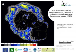
During 8 months, Thiebaut Levi-Funck joined our team as part of his 2nd year of Master’s degree in Tropical Environments’ Natural Hazards and Resources. His internship was supervised by both the University of La Réunion and the LIFE+ Pétrels. He worked on creating a predictive model of Barau’s petrel strandings all over the island. This model helps defining areas where the most birds strandings can be linked to light pollution. This model was realised by crossing the light pollution data from the VIIRS satellite and the petrels’ potential flight corridors. It allows us to run simulations on potential stranding numbers according to the locations thus defining the areas where the stakes are the highest. The first analyses reveals that 50% of strandings occur on 400m wide buffer zone on the coastline.
This work is a great tool to raise awareness on light pollution with decision-makers. A light pollution atlas is in progress and once it’s complete, it will enable us to visualise the high ecological stakes areas. We will then help municipalities towards a more adapted lightning strategy. These tools are vital to act on the island’s scale.
Lets not forget that urban lights can represent up to 40% of the electric bills of local administrations. Less lights mean more money saved !


